Thursday, December 24, 2009

Christmas Bird


I spotted a Hermit Thrush yesterday, enjoying his own Christmas tree. Bulbs and all. Wild rose hip decorations. I would be more accurate to say he spotted me first and his eyes locked on mine for 20 seconds or so, then he flew off into the dense brush up on the ridge. The Thrush was in a perfect Christmas pose but it was accidental. The Hermit Thrush normally feeds on insects but in the winter they add fruit to their diet. Perhaps the rose hips were a noon snack, which I so rudely interrupted.

Tuesday, December 22, 2009

Trekker of the Silver Sage


It was a great day for a hike in the Boise Foothills, and some of the fall colors were still hanging on, especially in the valley below. I took a picture of a Pin Oak, (Quercus palustris) which had been planted as an ornamental in front of some one's home, which was showing off its colors. The tree was a stout tree, about 40 feet tall, and many of the leaves were a robins breast-red color, blotted with a few yellows and light greens.

The foothills were in full winter dress, with only a few straggler cottonwoods in the creek bottoms, stubbornly hanging on to their yellow colors. The shade lines knifed deep into the canyons, with the December sun low on the winter horizon. The shady areas contrasted with the white snows and the green conifer trees on the far ridges. The dry bunch grasses dominated the hillsides, with scattered stands of bitterbrush and sage brush, and rabbit brush.

I hiked into what was the upper reaches of Freestone Creek, which reaches far into the foothills, knifing and gorging a snaky course to summit of the mountains. The hillsides were slick with mud in a few places and snow on the north slopes, which made for difficult footing.

The winter foothills grudgingly show colors, dominated by grays and browns. Granite-gray, atlantic-gray, tiger cat-gray, dust-gray, coyote-gray. Dirt-brown, soil-brown, wood-brown, dry-brown, sod-brown, dung-brown, adobe-brown. It may be dull looking but its full of life, if you know where to look, and it's excellent deer and elk wintering range. The bright colors will return in the spring, as dormant wildflowers and bunch grasses renew their growth.

Until then, I will wait patiently, through short arctic like winter days of Idaho, and keep my snow skis well tuned, and enjoy sluicing through deep powder-perfect snow!

Sunday, November 29, 2009

The stalk, the flight


The frigid November winds tore out of the northwest, bent on sweeping across the foothills to assault the conifer trees on the ridge top. The squalls stung at bare skin, and I pulled the hood of my shell over my head and closed it, and only a small part of my face was exposed.

The bunch grass waved steadily in the relentless breeze, in defiance of the cold. A thin shell of snow covered the north slopes, out of reach of the radiant heat of the sun, leaving the rest of the slopes painted in browns and grays. Scattered bitterbrush seemed to shrug off the wind like it didn't exist, its stiff branches poking fun at the gusts.

The wind was troublesome on the ridge top and I decided to side hill to the bottom of the canyon, and the footing was slick with snow and mud, making me step carefully to avoid falling. The winds slacked off about half way down, and a timid breeze wafted through the unwavering willows along the dry stream bed.

I kept a eye out for soaring hawks, but there were none to be seen, as if they were holding out for better flying weather. Who could blame them, for staying grounded, perched comfortably in some tall cottonwood, rather than attempting to fly into November gales, and muffing some spectacular aerobatic maneuver.

I spotted two mule deer across a low ridge, some 300 yards away, and I quickly dropped lower into the gulch, before they could spot me. The deer would be unable to catch my scent, because I was downwind of them, and that would make my stalk easier. I quietly walked across a swale and started up next rise, knowing the deer were near the top of the next ridge. I watched my footing carefully to avoid making noise, and stayed away from any brush that could scrape across my clothing.

I climbed the first small rise and spotted two deer with their heads down, browsing on shrubs. I inadvertently stepped a bit side ways and my pants legs rubbed together and with that smidgen of an alarm the deer looked up, their eyes locking on mine, and they started to move to the top of the ridge. I brought up my barrel and triggered the shutter and started to take pictures.

The two-some merged with 5 more muleys, that were hidden in a thicket and formed up in a herd, and suddenly one of the deer whirled around and started a downhill retreat, followed by the other deer in a straight line. The band headed towards the bottom of a deep canyon, running, bounding and leaping over rocks and shrubs, in what seemed an effortless motion.

I am always amazed at mule deer and how fine tuned they are to survival in rough and steep country, with steel like legs and fine tuned senses of smell, hearing and sight. They are quite adept at fleeing from predators, even ones armed only with a 300 mm camera.

Sunday, November 01, 2009

Following Lewis & Clark Through Wallula Gap


On a windy cold day this October we stopped at Hat Rock State Park in Oregon. I climbed the small hill below the basalt monolith called Hat Rock and took a couple of photos. The hill below the rock was covered with bunch grass and scattered bitterbrush and rabbitbrush mottled the slope. The Lewis and Clark expedition navigated down the Columbia River past Hat Rock on October 19th, 1805, on their trip to the Pacific Ocean. Hat Rock appears like a man made object, a totem or ancient megalith, and it stands in defiance of wind and rain, a survivor of dozens of humongous floods from eons ago, when Glacial Lake Missoula drained, pummeling the banks of the Columbia with 500 foot high waves laden with silt, sand, rock and icebergs. One would think that this small monolith would have been obliterated many decades ago, but the tough basalt armor has proved to be invincible.


Clark writes in his journal on October 19th, 1805.

".....14 miles to a rock in a Larb. resembling a hat just below a rapid at the lower Point of an Island in the Midl. of the river 7 lodges and opposite the head of one on the Stard. Side 5 lodges..."

Not far from that location Clark ascended a high cliff about 200 feet above the water and wrote

"....I descovered a high mountain of emence hight covered with Snow, this must be one of the mountains laid down by Vancouver, as Seen from the mouth of the Columbia River...".

Clark thought he had spotted Mt. Saint Helens but the high peak he saw was in all probability Mt. Adams, in the Cascade Range. Lewis and Clark were familiar with the voyages of Captain George Vancouver of the Royal Navy, and his explorations of the west coast and the Columbia River, and they must have been thrilled to see terrain that they previously read about. Vancouver had made note of several mountains from the mouth of the Columbia River but he also had sent an expedition up the Columbia River in 1792, lead by Lieutenant William Broughton. This expedition traveled as far as the Columbia River Gorge, sighting and naming Mount Hood.


We continued our drive to the north and entered the Wallula Gap, where the Columbia River knifes through a high basalt ridge that is several hundred feet higher than the water. The Lewis and Clark Expedition camped near Spring Gulch on the river, just south of the gap, on Oct. 18th, 1805 on their way west.

The day was cool and windy and the waters of the Columbia were sparkling blue, rippled by 2 foot high waves, and subdued within its channel of blackish basalt cliffs trimmed with brownish prairie. Just past the Wallula Gap the Walla Walla River taps the Columbia, marking another Lewis and Clark campsite of April 27, 28th and 29th of 1806.

There is a great deal of history in the Wallula gap area, of ancient Indian villages and trails and those of explorers, grown over with bunch grass or flooded by reservoirs. The geologic history is perhaps even more spectacular even though hard to imagine, that icebergs from what is now north Idaho and Montana, streaming through this narrow gap during an enormous flood, some 13,000 years ago. The refuse of a huge glacier breached by the Clarks Fork of the Columbia.

The only thing to dodge these days is the busy auto traffic on State Highway 730 but the views of Hat Rock and Wallula gap make this one of my favorite excursions.

Sunday, October 25, 2009

On The Border of the Sea


I spotted the sparrow gleaning insects on the lawn, near Heceta Head, by the historic lighthouse. The views at Heceta Head are some of the most scenic along the Oregon Coast, where the Pacific Ocean converges with tall cliffs and headlands, that are densely forested with Sitka spruce, western hemlock and lodgepole pine. The waves were busy as usual restructuring the beaches and granite bluffs and breaker after breaker washed ashore lunging and smashing into stubborn stone, in a relentless tumultuous roar, crash and thunder. Dark banks of fog, bear hugged the coast line, framing endless gray and whitish colored breakers, and a ribbon of blue sky wedged in over our heads.

We saw several whales just off shore, and they seemed to be lazily feeding, and rolling in the waves, showing only their backs, and the occasional spout of fine mist that appeared like a tiny geyser. The wafts of whale smoke drifted for dozens of yards with the wind, like some spot fire had been ignited, then quickly eradicated by vigilant waves. I guessed they were Gray Whales, on their annual migration, averaging 10,000 to 14,000 miles south to the Baja in Mexico. A population estimated at 22,000 animals, mostly found in the eastern Pacific Ocean. Their cousins in the North Atlantic were hunted to extinction many years ago, a staggering loss of an extraordinary mammal.

Later that afternoon we climbed down a rocky spine along the cliffs, where the ocean surf boiled up a narrow slot, a fracture in the granite wall. The water seemed to boil in this constricted cauldron as the one wave after another collided each other and the rock walls. A sea otter was spotted swimming in the white foamy gray waves and propelled forward by a large wave he jumped up on a dry ledge. Two smaller otters quickly followed and the 3 of them wrestled on the rocks, in mock combat but obviously showing great affection for each other. They seemed as comfortable on land as they did in the ocean, and several times they dove back into the water, reappearing several minutes later, sometimes with a fish.

After returning home I studied the pages in my bird book showing the different species of sparrows, of which there are many. Comparing the picture I had taken with the photos in the book, it looked to be a song sparrow but the match wasn't all the great. I did some looking on the web and and found that there are many about 24 subspecies or regional variation in song sparrows (Melospiza melodia), and they can vary widely in color and even size and the one I had seen spotted, looked to be of the pacific northwestern region type.

It was fantastic to see song sparrows feeding in the meadow adjacent to the ocean while at the same time being able to spot whales in the water half a mile away, and sea otters in both environments. The sparrow weighing in at 7/10th of an ounce and the Gray Whale up to 36 tons and the otter holding the middle ground at perhaps a whooping 50 pounds.

I never tire of visiting the edge of the sea, with its wilderness of waves and open ocean, and the birds, fish and sea mammals.

Saturday, September 26, 2009

Gray Wolves in Idaho; Changes in Attitudes

Photo Credit; National Park Service, Denali National Park

Last week I went on a back packing into the central Idaho mountains, and on the way home stopped in Stanley for a snack and gas for my truck. I happened to hear a conversation between several of the local folks about Gray Wolves. Their conversation started out how bad an idea it was to reintroduce wolves into Idaho and then went on to several other topics. From there they discussed how the Canadian Wolves were larger in body size than the native Idaho wolves, and how those vicious Canadian wolves had eaten all the local wolves.

The research on wolves and on other critters does indeed prove that as you move farther north in latitude that mammals get larger in size. Generally speaking. In other words, on the average a grizzly in northern Canada is larger than a Grizzly in Yellowstone Park. However to say that native wolves in British Columbia are larger than native Idaho wolves, is not very probable.

If you look at a road map there is nothing that separates Idaho from British Columbia besides an imaginary line, which is a wee bit insignificant to a Gray Wolf. From Canada to Stanley, Idaho it's about 500 road miles or 300 air miles. A determined Gray Wolf can travel up to 100 miles in a day, if there are no substantial barriers and if I do the math correctly a wolf could travel from British Columbia and arrive in Stanley Idaho, in 5 days. That fast of a trip is not likely because the wolf would probably have to stop and hunt and feed and they would avoid highways,towns and people and other wolf packs which would make it a long trip. The point is that wolves are very mobile and cover a great deal of territory in a short time.

Then the idea that Canadian wolves killing all the native Idaho wolves is interesting and somehow I envision the native wolves all wearing bright orange Boise State shirts, making them easy to find, and all the Canadian wolves wearing the Maple Leaf flag. This might make for a great story but there is no way for one wolf to discern the nationality of another wolf and they all have the same colors and there is no difference in their sizes. A Gray Wolf is a Gray Wolf is a Gray Wolf.

Then the conversation took a different turn that I never expected. One of the gals mentioned she had seen a Gray Wolf and she said "it was beautiful". In fact she said it twice. Then her husband was discussing how he was going to wolf hunting after the snows came on his snowmobile and it was something he was looking forward to.

Perhaps this signals a change of attitude and more acceptance of the presence of wolves in Idaho. Perhaps folks that weren't fully supportive of having wolves in Idaho are starting to take ownership and can see the value, magic, beauty, and the mystery of having wolves in our State again.

Sunday, September 13, 2009

Hag-Taper; The Orginal Pioneer of the West


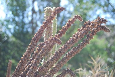
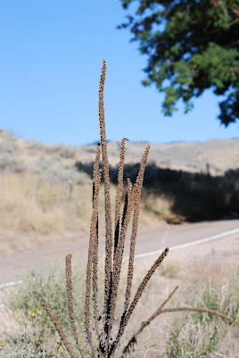
They were one of the first European pioneers in North America and probably the most tenacious, and they followed the footsteps of other discoverers along established roads and trails. Plowed fields and other areas newly disturbed my man were also a favorite place of settlement. Which pioneer was this? Well is was the Common Mullein (Verbasum thapus) of course, the plant honyocker, settler, homesteader and squatter, of the plant world. Some know this plant by the name of Hag-Taper.

The common mullein isn't native to the United States and was an introduced from Eurasia. It's a member of the figwort family and produces a stalk that is somewhat woody, unbranched and 2-8 foot tall, with yellow flowers that occur in dense , spike like racemes, with flannel like leaves. Mullein is classified as a biennial which means the first year the seed sprouts it forms a rosette of low growing silver-gray leaves and the second year it grows a long stalk with flowers, then the plant dies.

Mullein probably made it's first appearance in North America during colonial times when it was used as a medicinal herb and a wrapper for food, to keep it from spoiling. There are a number of other reported medicinal uses of this plant including treatment for coughs, pneumonia, and insect bites, which I cannot vouch for. The Indians of North America used mullein for tobacco, and healing smoke for respiratory problems and to make drill spindles for friction fire starting. Birds feed on the seed pods of mature plants, which provide a ready source of seed especially during the winter when the snows are deep.

In more ancient times mullein was known for magical properties and sprigs of mullein were passed through a fire in order to protect cattle from sickness brought on by sorcery. The Potowatami Indians smudged unconscious folks with the leaves to help revive them.

I often see mullein growing along dirt roads, and sometimes in open forest lands where fires have burned and in the canyons along the Owhyee River I have seen it growing scattered amongst the bunch grasses, like so many small trees. The soft leaf is one of the most remarkable features of this plant and it does feel like a piece of flannel. It's like you could use it to clean off your computer screen or even wipe the film off your glasses. The tall straight stalks remind me of a lance or spear, as if some ancient warrior stuck it in the ground to mark the way.

I think the most magical thing about mullein is its ability to grow in very dry areas, on disturbed soil and to grow so straight and tall. And as far as the medicinal uses, magic and sorcery I will leave that to others to fathom, but maybe I will keep a few mullein leaves around the house..... just in case.


Thursday, September 03, 2009

The Salmon River Breaks; the Granite Triangle


On July 19th, 2003, lightning ignited a fire on Cramer Creek, in the Salmon River Breaks of Idaho, on an impossibly steep grassy mountain, and a tragedy was in the making, as a series of small mistakes turned to disaster. The fire was discovered the next day and the shuttle of firefighters by helicopter began that afternoon, to the high ridges near the fire. The flames continued to eat away at the grass and brush on the steep mountain side and 200 acres were burning by the next evening.

There are places in the Rocky Mountains and other ranges in the world, that are almost impenetrable, due to the steepness and ruggedness of the country and the density of the trees and brush. This type of massif demands respect, and can only be ignored at your own peril. The landscape dominates the movement of animals and people, and trails intertwine and overlap, or there are no trails, just scrambles and technical traverses for the likes of mountain climbers. And mountain goats and bighorn sheep. Or you best not travel those slopes at all, unless you want to risk a fall or get bashed by numerous flying, tumbling and rolling rocks.

The Salmon River Mountains, located in central Idaho, are such a place. The Salmon River on its course to the Snake River cuts a deep canyon through rugged mountains dodging lofty peaks, and granite fortified ridges. The gorge of the Salmon is around 3,000 feet elevation and the peaks surrounding it are 8,000 to 9,000 feet in height, all in the space of around three or four miles. A hike from the river bottom to the summits is a gut wrenching, mind numbing experience with a full pack. Or even an empty one.

The Salmon River, also known as the River of No Return, originates in the snowfields and peaks of the Sawtooth and White Cloud mountains and flows a tortuous course to the north, until it reaches North Fork, Idaho, where the river turns abruptly and flows in a westerly direction. This area is generally known as the Salmon River Breaks or the Salmon Mountains. The lower slopes of these mountains are covered with grass and brush, which grades into timber as you climb in elevation. Spruce, pine, fir. The famous or maybe infamous Salmon River Breaks, is known as big fire country because fires spread so rapidly and the terrain is impossibly steep, rocky and remote. And deadly at times. River of No Return, indeed.

There have been many conflicts in this remote corner of the Rocky Mountains, between man and the mountains and all its elements of water, rock, ice, snow, avalanches, and fire. Explorers, warriors, mountain men, miners, river rafters and firefighters have tested their mettle in this wondrous land; tragedy and drama are no strangers.

My first experience in the Salmon River Breaks, was with a fire team on a wildland fire, located just north of the river. I drove the dirt road from North Fork to Shoup, Idaho, and the track narrowed the farther east I went and mountains seemed to push hard at the river, the granite flanks of the ridges literally diving into the waves. The fire assignment turned out to be a short one, but the chance to explore parts of the Salmon River Breaks, shall not be forgotten.

The Salmon River appeared like a silver ribbon enclosed in gray rock, with a wedge shaped piece of blue sky peaking through a gaping maw. The abyss is incredibly narrow and deep, leaving a fissure, or tear in the sky. The Salmon River does not surrender easily and fights back and roars at the rock, cliffs, and tangles of boulders and the waters tumble, roll, spray and froth with white. The rumble of rocks rolling on the river bottom and punching at banks and boulders is a symphony that drowns out all other sounds, and the sight of water rounded stones from ancient floods indicates the timeless power of the Salmon. The whitewater rapids rumble, crash, growl, snarl, and howl, in one of natures biggest shindigs.

On August 12th, 1805 the Lewis and Clark expedition entered uncharted territory into what is now Idaho, after crossing over Lemhi Pass, and Captain William Clark, for the first time, camped on waters that flowed into the Pacific Ocean. They were ecstatic to have finally reached this point on their long journey, but were soon dismayed to look out to the west and see one high mountain range after another.

The next day they traveled over rolling hills to the main Salmon River, where they encountered the Shoshone Indians for the first time. The Shoshones possessed horses which the expedition badly needed, to carry their cargo and trade goods, and trying to cross the mountains without these beasts of burden would have been nearly impossible.

The second part of their mission was to see if there was a water route they could take to the Columbia River by canoe. The Shoshones provided them with a guide and Clark and 3 men traveled another 40 some miles down the Salmon River and on August 23rd camped on Squaw Creek above the main Salmon River about 4 miles west of Shoup, Idaho.

Clark wrote in his journal:

August 23, 1805 "We Set out early proceed on with great dificuelty as rocks were So sharp large and unsettled and the hill sides Steep that the horses could with the greatest risque and dificulty get on .."

.... below my guide and maney other Indians tell me that the Mountains Close and is a perpendicular Clift on each Side, and Continues for a great distance and that the water runs with great violence from one rock to the other on each Side foaming & roreing thro rocks in every direction, So as to render the passage of any thing impossible. those rapids which I had Seen he said was Small and trifleing in comparison to the rocks and rapids below......"

The Shoshone guide indicated there was a better route, which traveled north to the Bitterroot Valley, and heeding that advice, Captain Clark sent a messenger back to Captain Lewis, telling him there was no passage down the Salmon River. Clark and his men retreated back up the Salmon River and on August 27th they met up with the main expedition and Lewis. They charted a new course up the North Fork of the Salmon River, and started the tortuous climb into Bitterroot Mountains to Lost Trail Pass.

The Lewis and Clark expedition, with the help of the Shoshone's, evaluated the risks of traversing the Salmon River and made a good decision, to retreat to the north. They had met their match in the Salmon River Breaks and the mountains had won, and it was to rugged for even the likes of seasoned Indian guides and their ponies and mountain men.

During the journey across Lost Trail Pass, Clark Writes in his journal:

Sept. 3rd, 1805. "....hills high & rocky on each Side, in the after part of the day the high mountains closed the the Creek on each Side and obliged us to take on the Steep Mountains, So steep that the horses Could Screcly keep from Slipping down, Several Sliped & Injured themselves....."

There are many lessons to be learned from the experiences of Lewis & Clark and the Shoshone Indians, for those that cared to listen. In August of 1985 hundreds of firefighters would encamp in the Salmon River Mountains, to fight dozens of lightning ignited fires.

One of those blazes was the Butte Fire which was 10 miles, as the crow flies, from Squaw Creek drainage on the Salmon River where William Clark and his party turned back in 1805, due to the ruggedness of the country. On the afternoon August 29th, 1985, a crown fire run boiled up in Owl Creek and Wallace Creek and the fire lunged to the north towards the ridge top, at Tin Cup Hill, where hundreds of fire fighters were constructing control lines. 118 firefighters were entrapped on that remote mountain and surrounded by a firestorm, that roared like 100 freight trains and burned for hours with multiple flaming fronts. 78 of those firefighters used their fire shelters to escape the heat and smoke and all survived, huddled on a mountain 10 miles from the cool waters of the Salmon River. There was considerable drama that day but none of it ended in a tragedy, but it goes down in the history books as one of the biggest fire entrapment's ever. The Salmon River Breaks and its seemingly invincible ridges and thick timber, won the day and thoroughly rejected, trounced, thrashed and routed the firefighters and forced them into full retreat.

And the story does not end on Tin Cup Hill. In July 19th of 2003 a lightning fire started on Cramer Creek, 4 major drainage's to the west from where the Butte Fire occurred in 1985. A contingent of firefighters was sent to fight a fire, on yet another ridiculously steep, rugged and rocky mountain in the Salmon River Breaks. It was a perfect furnace, like a huge wood stove with its mouth at the cool waters of the Salmon River at 3100 feet and a mountain above at nearly 8,000 feet, forming a stove pipe that reached for the sky. A 5,000 foot tall furnace a couple of miles long and a mile wide, stoked with extremely dry grass, brush and timber. Into that pyre walked a few dozen firefighters, and two never returned. Heroes to us all.

The Cramer Fire occurred about 22 miles downriver from the location in 1805 where William Clark started his retreat back to the east and north. Clark made the determination, with the advice of the Shoshone Indians, that neither horse nor canoe could safely traverse this area.

The Butte Fire, the Cramer Fire, and the path of Clark William intersect within a triangle of mountains, in an area I call the Granite Triangle. The triangle is formed by drawing a line from the Shoup, Idaho northwest to Tin Cup Hill, then connecting that line to Long Tom Mountain, with the Salmon River forming the bottom. In this region the historic footsteps and helicopter flights of firefighter and explorers merge and cross, which is no accident. The mountains are guarded by some of the steepest and rugged slopes in the world, nearly unconquerable, and a river that has to knife its way down a wedge of canyon, and literally fight its way through boulders and around rock ledges.

On Sept, 3rd, 1805 Clark wrote in his journal:

"..This day we passed over emence hils and Some of the worst roade that ever horses passed our horses frequently fell....."

Over the years I worked on many forest fires in the Salmon River Breaks and the beauty and ruggedness of this region, always continues to amaze me. It's a special treat to see the wildlife, especially the sight of bighorn sheep clambering across rock slides with their exquisite camouflage, the same grayish color as the granite boulders. My path has crossed the Lewis & Clark and Shoshone Indian trails many times, and roads and trace of historic fires.

On a summer night above the Salmon River, somewhere near Owl Creek, you might hear, if you listen real hard, the chatter of firefighters on a nearby hill and the whine of chainsaws, the whinny of a horse, the sound of drums, or a desperate transmission over a two way radio, or the fleeting movement of a line of horses and buckskin clad men on a far ridge. Or maybe its just a rock or log tumbling down the hill, or an owl hooting, a wolf howling, the rumble of whitewater, the wind in the trees and sweeping over granite ledges, or a herd of elk running single file down a ridge. Echos and shadows of Indians, woodsmen and explorers.

Wednesday, September 02, 2009

Concerns About Wild Wolf Attacks in Idaho

In a recent letter to the editor in the Idaho Statesman, one of the authors was concerned about the danger of wolves in Idaho, and were considering not riding their horses in the mountains. Certainly wolves are a wild animal and can be dangerous but there are many dangers in the mountains including rushing rivers, rolling rocks, falling trees, lightning, mountain lions, bears, bees and moose. You have to put these threats and dangers into perspective. Take a look at attacks by domestic dogs, which by some estimates there are 26 people killed every year. The number of wolf attacks in the United States per year, averages just about zero. Now granted there are many more domestic dogs than wolves but the bottom line is domestic dogs have no fear of humans. Wolves generally fear humans, and will stay away, but they are curious and sometimes and will approach people. I personally feel safer in the mountains than strolling around town. Hiking and hunting in the wild Idaho is all about looking at the scenery and wild animals. You have to be wise to the woods and take precautions but seeing a bear or wolf is a real thrill.

Tuesday, August 18, 2009

Idaho Fish and Game Commission Sets Wolf Hunt

Photo Credit: Alan Wilson; Naturespicsonline.com

The Idaho Fish and Game Commission (IDFG) recently announced the quota's for the fall wolf hunt in Idaho, and there will be a statewide harvest of 220 animals, out of a total estimated population of 740 wolves. Separate quotas have been established by hunting zone and once the quota is met then hunting will be suspended in that unit. Tags will go on sale on Monday and the hunt will commence on Tuesday. If the harvest levels are met it reduce the Idaho wolf population by about 25%. This announcement has already been challenged by the Defenders of Wildlife, which will seek and injunction. In comparison the State of Montana annouced a wolf harvest limit that would take at the most, 15% of the total wolf population.

IDFG and other State of Idaho officials have been inconsistent in previous announcements concerning the wolf harvest, with some officials supporting a kill of over 400 animals.

Establishing a hunt for wolves is a good idea, if the take of wolves is regulated to keep harvest levels in line with what the total wolf population can support. Killing 25% of the wolves in Idaho is not sustainable and will result in a decrease of wolf populations across the State of Idaho.

Hunters have a great deal of stake in this issue and having their support to keep a viable wolf population is critical. The numbers of elk and deer populations have been fairly stable for the last 10 years, in the face of increasing wolf packs. This is because the wolves kill animals that would normally die anyway of starvation, disease or winter kill. Where wolf packs exist in Idaho the herds of elk and deer are much stronger because the weaker animals have been culled, and the big game animals are better able to survive predator attacks, disease and long winters.

There is great irony in the number set for harvest of 220 wolves in Idaho. In comparison the entire wolf population of Yellowstone Park was estimated at 128 animals, in 2008. Do the citizens of Idaho support the kill of 220 wolves, which is nearly twice the total population of the wolves in Yellowstone Park? I think not.

A wolf kill of 220 for Idaho is not sustainable nor reasonable, and the IDFG would be be wise to follow the lead of the State of Montana. It is not likely that hunters will harvest the maximum number of wolves allowed, but setting those numbers so high, is not wise. The howls will follow.

Monday, August 17, 2009

Flying Pine Cones of the North Woods


Only a forester or camper would marvel at a ponderosa pine cone. Maybe a firefighter. Or kids rollicking and frolicking in the woods. A pine cone lying on the ground is a natural attraction for children (and probably adults) and they fit nicely in your hand and have a heft and feel that makes them easy to throw.

A ponderosa cone at maturity is about 5 inches long, and 3 inches across at its base, and somewhat pear shaped. The cones, are the fruiting body of the pine, and they are born high in the tree tops in the spring, and produce seeds that fall to the ground and produce new trees. The cones grow quickly and initially are a purple greenish color and mature in two years, turning brown and eventually fall from the tree. Cones have a central axis which is surrounded by overlapping scales and they are armed with a fine point on the end. Small spears that offer protection for the seeds of the pine, from marauding birds and mammals. The seeds are fairly large for a conifer and have a wing that is about one inch long. When the cones open up at maturity the seeds are free to fly and drop to the ground and the wing gives them a boost in seeking new territory.

As kids growing up in the Flathead Valley of Montana we had many a pine cone fight as the ponderosa pine (or pondos as I call them) provided an abundant source of weaponry. We would gather a bunch of missiles and the fight was on, until you ran out of projectiles, but they were abundantly available under most of the pondos. The trees offered cones and also shelter from the barrages of the opponent that was stalking you. We did not intend to harm each other except for an occasionally neighbor kid that would decide to inflict pain by throwing the hardest cone they could find. The deadly green cone that was about as hard as a chunk of granite, complete with sharp spines. The brigands were soon banished from our group.

The cones are also handy also for starting a camp fire as they ignite and burn quit readily. However this feature is not appreciated by firefighters that construct fireline in the woods on steep mountain sides and have to deal with rolling burning cones that can roll across firelines causing the fire to escape.

The American Indians of course were quite familiar with pondo cones, and surely they had many uses for those brownish orbs, and there is at least one game that was played that involved throwing pine cones through hoops. One of the first written descriptions of ponderosa pine was by David Douglas in 1826 in northeastern Washington State. He was however not the first. William Clark of the Lewis and Clark Expedition noted the presence of ponderosa pine cones on the White River of what is now South Dakota, on Sept. 16th, 1804. Washed there from its upper tributaries. The first written observations of the ponderosa pine were made by the Spanish explorer Coronado in the southwest united States in the mid 1500's when his soldiers started to use the name Ponderosa, because the trees were so large large and “ponderous”.

What are the origins of the first pine cone fight? It must have occurred very early in mans existence, deep in the mountains of Africa or Europe. What about in North America? Perhaps the first skirmish occurred in 1805, in the Rocky Mountains, when William Clark, annoyed with Meriwether Lewis, hefted a pondo cone and heaved it at his friend. I have no proof.......but just maybe.


Saturday, August 01, 2009

Bison Crossing the Cutthroat Trail


It's a sunny day in Yellowstone Park and I stand on a bluff, looking down at the Lamar River, which appears like a wide silver ribbon, speckled with giant boulders, and framed on both sides by rolling hills colored with silver sagebrush. The Lamar River meanders to the west, on a snaking course to the Yellowstone River, through rugged timbered mountains, and dark canyons.

Herds of buffalo, or bison, dot the Lamar valley, the Serengeti of the mountain West. Buffalo ground. On the drive up the Lamar we passed a couple of herds that were lingering near the road, the adults a dark brown color, with short curved horns, high shoulders, and odd shaggy patches of hair on a few of the animals. The bison calves, reddish-brown in color, are born in late April or May, and they shadow the sides of their moms, always on the lookout for sneaky Grizzly bears or packs of wolves.

Large bulls roam around giving out an occasional bellow, seemingly inspecting all they animals around them. They are close to entering breeding season, and the bulls will soon become very possessive of their herds and brawl and clash with other males in dusty head butting duels.

My wife Louise and I decided to hike into a quiet spot on the Lamar River in Yellowstone Park, in search of the elusive cutthroat trout. We parked the truck on the road and hiked up a bunch grass and sage covered knoll, following a sandy, well trodden buffalo trail, treading through a few recently tended wallows. The wallows were several feet across and formed a circular depression a couple of feet deep. The bison, or buff, had been busy at wallows, trundling, stirring and stomping the soil to a fine dust, then rolling in the powder, to tend their hides and scrape off pesky bugs and unkempt hairs.

Looking to the north I can see several patches of snags or dead trees, and probably half of them have fallen to the ground, spore of the fires of 1988. The woody boles of the downed trees, line up in a northeasterly direction, and apparently strong sou' wester winds have mowed them down, with unknown purpose. I wonder if it's natures design to have all snags fall to the east, as if the mountain gods must be appeased.

The standing snags are a silvery, gray color and many of the dead branches have fallen off, and they look like porcupine quills. Humongous quills, 60 feet tall. As if some giant porcupine swatted the hills with its tail, leaving swaths of quills stuck in the rock and sand, in hundred acre chunks.

We continued on the buffalo trail, following a low ridge to the north until we discovered a side path to the Lamar river, that wound its way through a wet meadow or cienaga, with tall, dense grass and hidden seeps of water. At the river the trace followed along the cut bank, the trail stomped in the tall grass, with a few deep footprints in the mud.

We came to a breach in the cut bank where there was a sandy beach with an easy access to the the waters edge, which was obviously a ford for the buff to cross the Lamar River, and on the opposite bank I could see a wide trail coursing up the steep bank. The river was very clear with a slight greenish tinge, lined with rocks and gravel and a sprinkle of large granite boulders with quiet deep eddies of water in their shadows. The hideout of lunker trout and the lair of the fly fisherman and an occasional grizzly bear, also known as a “silvertip”. This trace has probably been used for hundreds or thousands of years by herds of buffalo and elk, with its strategic geographic location.

There were a couple of large whitish colored bones laying in the sand, probably from a buffalo and nearby more bones buried a two feet deep in the rich dark loam soil, deposited by water over the eons. Historic bones of drowned or winter killed buff or elk, or the ancient kill of prairie warriors. Newly printed deer, buffalo, and sandpiper tracks marked the beach, a watering hole for thirsty animals, or birds in search of sneaky but tasty bugs.

I unlimbered my fishing rod, rigged up a bug, and soon had my fly line weaving with the blue sky in arching patterns, and delicately landed a dry fly on the rippled surface of the river. A series of large boulders, in the water, made for great trout habitat, with deep waters and eddies on their downstream side. The water was crystal clear and the winds were light which made it easy to watch the dry fly float down the stream, in a seemingly perfect ruse or deception, for a hungry fish looking for a meal of an insect. It doesn't get any better for fisherman.

I fished for a couple of hours, keeping an eye out for wandering buff and silvertips, to make sure there wouldn't be any accidental encounters, with stomping hooves and sharp teeth. My catch of cutthroat at the end of the day is slim, but the fishing was fine, and I snared a heap of memories, of silvery waters, mountains, herds of buffalo and a grand picnic on the banks of the Lamar.

Walking back to the truck at the end of the day, I stop at a buffalo wallow and mull over the existence of buffalo, and a couple of hikers, and wonder if perhaps there is something to a good roll in the dust. After all, look at the bison and how large and healthy they look and maybe all that powder does a body good. Pondering my gray beard, perhaps I qualify to get down on all fours, roll in the dust, and pulverize and pound some perfectly good soil into powder, and kick up a few dusty geysers. Maybe another day.


Sunday, July 19, 2009

Crazy Horse


It's a beautiful blue sky day in the Black Hills of South Dakota, as I stand on the observation deck of the Crazy Horse Memorial, looking out at Thunderhead Mountain. This mountain of granite rock is being blasted, chiseled and carved, into a sculpture of the famous American Indian, named Crazy Horse, an Oglala Lakota warrior. There is a smaller scale model of the sculpture, of how the mountain will eventually look, that sits on the deck, and it's about 15 feet high, and a pure white color. The observation area and museum are very busy and the visitors are milling about looking at the view and the exhibits, but it's a different kind of crowd and they seemed quiet and respectful.

This project was the dream of sculptor Korczak Ziolkowski and his family, and it was started in 1948. This massive sculpture will depict the upper body of Crazy Horse, his arm pointing to the east and the head and neck of his horse, and will be 563 feet high and 641 feet long. In comparison the carvings of Presidents on Mount Rushmore are 60 foot tall. The face of Crazy Horse is now completed and it's 87 feet high, and work continues on blasting and forming the rock. The Crazy Horse sculpture is a work of geometry, of lines, circles, triangles and curves, which is constantly evolving. A work of art, on an immense scale.

I spot something moving on the mountain just to the side of where the horses head is being carved, and at first I thought it was one of the workers on the mountain but it wasn't. It was an animal with 4 hooves, two black colored horns and its a whitish color; a wild mountain goat. The mountain goat is oblivious to his surroundings and he turns in a circle and lays down, only interested in taking a nap, in the shade of the cliff face, that eventually be formed into the nose of a horse. This is a place of refuge, on these high cliffs, where over the eons the mountain goats have sought refuge. Crazy Horse would approve of the presence of these magnificent animals.

Crazy Horse was born in 1840 and was killed in 1877, while a prisoner of the U.S. Government. Crazy Horse was a famed warrior that fought many battles with great distinction, and was known as leader and strategist in battle and he fought in many of the most famous engagements across the West including the Wagon Box fight, Fetterman fight, Battle of the Rosebud and the Battle of the Little Big Horn. Crazy Horse fought for the Indian People and his tribe against the U.S Government, so save their way of life, their land and hunting grounds. His most famous encounter was with the 7th Calvary at the battle of the Little Big Horn or the Battle of Greasy Grass Creek as the Indians called it.

General Custer and his command of 210 soldiers were attempting to flank the Indian Village along the Little Big Horn River, but they first had to find a ford and a way around the steep cut banks. Before that could be accomplished the Indians attacked their flank and pushed the soldiers back up the hills, where they fought a desperate last stand. Crazy Horse led a flanking assault, with a large group of warriors, at a place now called Custer Hill, which effectively ended the battle, and swept Custer and 210 troopers to their death.

Crazy Horse was very resolute in his determination to fight for his people, and their lands, even in the face of impossible odds, but he would never give up his fight, to keep the Black Hills. I see the Crazy Horse Memorial as more than a massive granite sculpture, but a permanent marker, a mountain of art and protest, a hard rock heap of determination, that the Tribes will not give up their struggle for the Black Hills. The eyes of Crazy Horse look out over the Black Hills, in a timeless gaze, watching over the creeks, meadows and ponderosa pine forests. A steadfast and stalwart lookout.

The shadow of a warrior on a horse, rides the pine forest late in the afternoon and wedges across the landscape, as the wind howls and curls around Thunderhead Mountain. The crackle and sound of footsteps in pine litter breaking sticks. I take one last look at the sculpted mountain, and stand it awe of the man, and the monument.


North Country Prairie


Photo Credit: Claranne Baddeley

The wind blows across the prairie of North Dakota and the grass sways in emerald green waves, like an incoming tide sweeping in off the ocean. The only sound is the wind and the chattering of red-winged black birds down in the slough and the chirping of gophers, Richardson's Ground Squirrel.

My wife Louise and I are staying at the Baddeley Ranch, which originally was owned by her parents, Hazel and Lloyd Swensrud. Louise and her sister Claranne were raised on the farm. Claranne and her husband Charlie recently purchased the ranch and are raising horses, angus cattle and longhorns. Louise, Hazel and myself are spending a few days at the ranch visiting.

The ranch is nestled behind two small rounded hills, on the rolling prairie of North Dakota. About 10,000 years ago, continental glaciers swept north over this region leaving a landscape of undulating hills, small lakes and ponds. The soils are generally deep and laced with sand, gravel and rock and scattered large boulders called erratics are quite prevalent. Glacial debris.

Claranne gave me a couple of pictures of the ranch and the first one shows longhorn cattle with the ranch buildings in the background, on the wide open prairie. The second picture shows Claranne's husband Charlie and their daughter Linea, on horseback. Linea is riding a horse named the Ragin' Cajun, with a saddle that was owned by her grandfather. Charlie is riding a horse named Gone Physco. In the foreground of the picture is an old horse drawn one-bottom plow that Hazel and Lloyd used for farming, many years ago.

The prairie grass has gotten off to a slow growth this year after a hard winter, with lots of snow, which will make for smaller hay crops. The small ponds and lakes are brim full of water, which will make for great nesting habitat for ducks, geese, swans, red-winged blackbirds and shorebirds. In the fall the adult birds and their young will take flight to more moderate climates.

The weather is king, in the north prairie country, and the seasons dominate the activities of the local residents. Summer brings hay cutting and tending of crops followed by fall which is harvest time for wheat and other crops. Winter seems endless with arctic like conditions of frozen ground and snow followed by the miracle of spring with the regrowth of the grasses, new calves on the range, and brand-new flocks of baby ducks. The timeless cadence of life on the prairie.

Thursday, June 25, 2009

Mocassin Trails Under Hawk Shaddows


Growing up in Montana and living in the northwest, I often find my path crossing with the trails of the Lewis and Clark expedition. In 1805 the expedition traveled up the Missouri River, crossing the Continental divide and wintered on the Pacific Coast of Oregon. In 1806 they left the coast in the spring, working their way up the Columbia River and its drainage's, crossing back over the continental divide, then down the Missouri River and Yellowstone Rivers making their way back to St. Louis, Missouri. Their accomplishments were remarkable and they covered a huge geographical area with the help of their Indian Guides.

This summer we decided to follow a portion of the Lewis and Clark trail over Lemhi Pass, from Idaho into Montana. Leaving the paved road at Tendoy, Idaho, we turned onto a gravel road that follows Agency Creek. The road heads east and crosses the famous Lemhi Pass, about a 24 mile trip from pavement to pavement. The canyon is very narrow, lined with dense brush and cottonwood trees, and the water in the creek was running high, cold and clear. The lower end of the canyon is steep with open prairie.

About half way up the canyon we came to a Forest Service signpost that indicated the location of the first encampment in Idaho, for the expedition. On Monday August 12th, 1805 Lewis and 3 of his men, in an advance party, traveled west over Lemhi Pass, and camped at that location. The continued their trek the next day, leaving Agency Creek following the Indian trail that climbed to the top of the main ridge to the south.

We continued our trip up the mountain on the narrow winding road. Silver sage dotted the green, grassy slopes and the north facing slopes became heavily forested with Douglas fir, lodgepole pine, spruce, and small stands of aspen. At the top we reached Lemhi Pass, which was fairly open with spectacular vistas in several directions.

At 7,373 feet Lemhi Pass is an ancient gateway, a hole in the mighty Bitterroot Range, the continental divide separating the waters of the Pacific from the waters of the Atlantic. This passage was well known to the Indian tribes and their well worn paths traversed this gap. Lemhi Pass is a convenient passageway through this region, and the boots of mountain man, pioneers and stagecoach wheels soon followed the moccasin traces, in the decades to come.

The Lewis and Clark expedition was overjoyed to reach the headwaters of the Missouri River after toiling for many months, towing, poling and rowing their canoes upstream. They had hoped to find an easy water passage by canoe to the Pacific, but what they saw looking out to the west from the top of Lemhi Pass was one snow capped mountain range after another. An endless archipelago of peaks and ridges. The only water route through this region to the waters of the Pacific was the Salmon River which was impassible by canoe or horse.

I heard the screech of a hawk and spotted two Red-Tailed Hawks flying in tandem directly over the pass, as if they were playing tag, darting back and forth, wingtip to wingtip. Perhaps it was a mother hawk teaching a young bird the finer arts of aerial acrobatics or a mate teasing its partner. The birds lingered over the high ridge, in a timeless ritual of gliding wings, propelled by thermal updrafts, against a hazy blue sky.

The paths of warriors and pioneers has long grown over by bunch grass and trees and only the gravel stage coach road remains, and the remembrance of explorers and hunters. The view from the pass was spectacular, with mountains in all directions, many of them snow capped, and shawled with forest. It was quiet with only the sound of the wind in the tree tops, and the birds at play. We didn't see a single person on our passage over the mountains, which was all the better as far as I was concerned. Lemhi Pass is a place I could linger for several days, in all its natural splendor. But like Lewis and Clark I have places to go, trails to conquer and journals to write.

Saturday, June 13, 2009

Buffalo Trace on The Chinook Prairie


I have always enjoyed trekking the prairie of eastern Montana. On on particular trip I drove north of Chinook, Montana, towards the Canadian border. The medicine line. I had a map showing federal lands and I was searching for undisturbed prairie. A chunk of bunch grass wilderness.

The road bed was gravel and my car kicked up a plume of chalky colored dust. I found a wide spot in the road to park and headed out on foot across the flat prairie, on no particular path, intent on exploring and wandering. To the south, about 30 miles away, I could see the high peaks of the Bears Paw Mountains at 5,000 to 6,000 feet. The summits are scarfed with black patches of timber; douglas fir, subalpine fir and ponderosa pine and the creek bottoms are lined with wild rose, chokecherry, service berry and willow.

The prairie I was hiking was about 2,600 feet in elevation, on a level plain, with an occasional shallow drainage, most of them dry, and a few stock ponds and small lakes, that shelter ducks and shorebirds. The prairie looks flat but it's quite deceiving because there are hidden arroyos which you can't see until you get out and start hiking. I continued my trek, wandering towards the east and my truck was soon out of sight. The sky was a dark indigo blue color and cloudless, and it was a fine day to be out.

The prairie seems trackless but there are a many over grown trails of buffalo and elk, Indians, cowboys and whiskery runners. The prairie is dominated by grasses, typically, buffalo grass, grama, wheatgrass, and needlegrass and the home of mule deer, pronghorn, jackrabbit, prairie dogs, coyotes, fox, 13-lined ground squirrel, badgers, sage grouse, sharp-tailed grouse, and greater prairie chickens. Long gone are the buffalo, wolves and grizzlies.

It's so quiet on the high plains you can almost hear yourself think. The limitless horizon is daunting, and it seems to swallows you alive. Some find it lonely on the prairie but I find it exhilarating. Often the only noise is the rustling of wind across the dry stalks of bunch grass, and the occasional screeching of a Red-Tailed Hawk, "keeeeer keeeer". Or the whistling sound made by the wings of a brace of teal, flying low headed for scarce water.

A Horned Lark landed on a nearby perch, and stared at me, as if I am disturbing his peace or invading forbidden territory. The lark, in his bandido like outfit (minus the sombrero) looked directly into my eyes, warning me to flee his prairie empire. The Horned Lark has very unique coloration with black like horns, a dark mask and a conspicuous black breast band under the throat like a bandanna. The Lark lingered for a few minutes, giving me the evil eye, and I decided to move on, and end my intrusion on it's nesting territory.

At night the vast prairie of eastern Montana is wall to wall stars, planets and meteors. The Milky Way dominates the sky from horizon to horizon and northern lights often dance the sky shimmering, shaking, waning and waxing. The Indians have a belief that the northern lights are our ancestors, coming back to visit.

I walked slowly through the short grass and kept one eye to the ground, looking for interesting rocks or other objects. Much of northern Montana was glaciated by continental glaciers, leaving a wide diversity of rocks and minerals, in its wake.

I spotted something on the ground, out of the corner of my eye that looked odd. The object had a curved shape and it was a horn. I thought perhaps it was from a domestic cow but it was a horn from a buffalo. A trace of the ancient herds. The outside surface of the horn was badly eroded and flaked but it retained its shape and heft. I decided to keep the buffalo horn put it in my pack.

13 million buffalo, once roamed Montana. By 1883 buffalo had been exterminated by hide hunters with one of the last massacres occurring in northern Montana in the Sweetgrass Hills. A few remnant herds were protected in Yellowstone Park and on the Flathead Reservation and exist to this day.

I crossed a shallow ravine, crawling through thick brush, and a few hours later turned and headed back to the west, towards my truck. I hesitated because the terrain looked very unfamiliar with no distinguishing landmarks, except for the Bears Paw Mountains, way off to the south. I knew I had to hike in a westerly direction but I wasn't sure where my vehicle was. It was a warm summer day and I had plenty of time to find my way, and to scout new territory. Ahhh, the life of the high plains drifter.

Wednesday, June 03, 2009

Playing at the Bottom of Glacial Lake Missoula

I grew up in the small town of Pablo, Montana and as kids we played at the bottom of a lake, that was at one time, 2,000 feet deep. Covered by waters and glaciers. This huge inter mountain lake was an ice age relic, that disappeared about 13,000 years ago. Glacial Lake Missoula. Pablo is a small town in the Flathead Valley and is located directly adjacent to the Mission Range, a magnificent archipelago of alpine peaks and forests. Geologic research has shown that the massive Cordilleran ice sheet or glacier, covered even the highest peaks of the Mission Mountains, some 4,000 feet deep, as far south as the Pablo area.

The glaciers are mostly gone now except on some of the highest peaks of the Missions.

Glacial Lake Missoula was formed when the Cordilleran ice sheet moved south and blocked the Clarks Fork River near the Idaho border. A huge lake was formed behind the immense ice dam and its waters spread 200 miles to the east, with major lobes to the north and south. Lake Missoula at its peak covered 17,000 square miles, and inundated parts of several major river valleys including the Clearwater, Blackfoot, Clarks Fork, Bitterroot and the Flathead. Research has shown that this ice dam was breached by waters of Glacial Lake Missoula at least 40 times, creating huge floods the inundated eastern Washington and Oregon, following the Columbia River to the sea. This ancient lake and the ice sheets are long gone but a great deal of evidence was left in its wake, including Flathead Lake.

As kids we knew little about geography, but the traces of momentous geologic events was everywhere. Not that we cared as we were just interested in playing and exploring. There was a sandy area in our back yard and we dug pits, trenches, tunnels, piled up mounds and scraped shallow canyons. It was easy digging with nary a rock to be found. I remember many times digging furiously down through those soft layers, to see how deep I could go. The bottomless abyss. In reality my excavations probably never reached a depth of more than 4 or 5 feet, before supper interrupted mining operations. We were like a bunch of badgers rooting around and digging in the sand.

We constructed highways, bridges, tunnels, towns, forts, mountain ranges and canyons in the sand and raced our toy trucks and cars through a make believe world. These fine feats of engineering usually disappeared a few hours later, covered up by newer endeavours or simply stomped on or blown away by spurious winds.

This ocean of sand in the area around Pablo, was lain down by streams, rivers and floods from melting glacial ice or silt deposited at the bottom of lakes, which then drained away leaving a flat sandy plain.

Then there were the tunnels the older kids had dug, that were so narrow you had to belly crawl through them. These adits were dug horizontally in the soft sand and were about 8 feet below the surface, and 10-15 feet long. I was very fearful of venturing into those shafts and never lingered long in those dang, dark tombs. The soft walls and ceilings could have easily collapsed, snaring us permanently in glacial debris.

There were scattered ponds in the valley, that were formed during ancient glaciation, from huge chunks of ice left behind by retreating glaciers that melted, leaving permanent lakes. Sometimes called pot holes. The lakes and creeks abounded with fish, ducks, geese and shore birds and were a delight to explore and investigate. We plied these waters with our home made fishing poles, pursing devious cutthroat trout and in the winter dusted off our ice skates and spent many hours gliding and sliding on the thick ice.

In the winter we would snow sled at a place we called Big Mountain, after the ski hill up north at Whitefish. Our sledding hill was a series of small mounds which were probably glacial moraines; areas of rock and sand literally bulldozed up by ancient glaciers. The hills were heavily forested with dark green Ponderosa pine, and a couple of miles to the west, rose the foothills of the Mission Range.

The Mission Mountains shadowed over us with its towering peaks, ridges, glacial horns, cirque valleys and rushing clear water streams that roared down white water rapids. Glorious stands of pine and fir covered the mountains and parts of the valley floor and many a youthful expedition traversed the hidden glades and towering stands of yellow pine.

Cataclysmic geologic events sculpted the Flathead Valley and surrounding mountains and created a wondrous landscape and it was an incredible place to come of age. I probably still have glacial silt embedded in some of my toys that have survived my childhood and many fond memories of romping at the bottom of ancient lakes.

Thursday, May 21, 2009

The Siberian Express Rolls Over Haystack Butte


The coldest winters I ever experienced, were in eastern Montana. One day in particular, back in the early 1980's, when I lived in Havre, Montana, the wind chill factor was 100 degrees F. below zero.

The winds were screaming that day and even inside a heated building you were cold, and a heavy sweater didn't help much. If you faced the wall your front was cold and your back was warm. Cold pressed into the walls like spears of glacial ice were about to stab through the building, and into your body.

The story of 100 F. below zero wind chill factor, was probably an exaggeration, but I suspect it wasn't far off. To obtain a wind chill of -100, the temperature has to be - 45 degrees or colder, with winds over 60 miles per hour. That combination is possible, on the high plains.

The Montanans call the big storms and cold fronts that roar in from Canada, the Siberian Express.

Another memorable freeze-out, was the time I climbed Crow Peak (9,300 feet elevation), in Montana, back in January of 1973. The main summit of Crow Peak is above timber line, with no trees except for a few gnarly patches of krummholz. In German krumm means “crooked, bent, or twisted” and holz means “wood”. The fierce winter gales, and extreme low temperatures of Montana winter, turn high elevation trees into stunted low growing shrubs, that take foothold in the lee side of large rocks, or low spots in the terrain. An arctic environment. The lower elevations are forested with lodgepole pine, aspen, spruce and limber pine.

Four of us snowshoed into Leslie Lake, at 8100 feet, and stayed two nights at an abandoned miners cabin, which was in disrepair but offered 4 walls and a roof and an old wood stove that was functional. I suspect that the cabin is long gone, crushed by deep winter snows or ambushed by avalanches. Or torn down by looters. We took a day trip and ascended Crow Peak, on snowshoes, and once on the summit the wind was screaming, and it was incredibly cold. A retreat was in order. I had taken off my snowshoes and when I attempted to strap them back on I was unable to, because my hands were so cold. Numb and almost useless. One of my friends luckily had nimble enough hands to help me buckle them back on and we were soon traversing our way back to the cabin.

A couple years later two of my friends decided to mount a winter expedition to Leslie Lake. On the return trip out they attempted to cross a steep and icy slope, and they were unable to kick footholds with their skis and snowshoes and every step they slid a few feet closer to the bottom of a gorge. Each slip brought them closer to trouble and calamity. Darkness bore down and they were forced to bivouac in the canyon bottom, in several feet of snow. In the seemingly endless arctic night of Montana they huddled and shivered together, in one sleeping bag. With frost bitten feet, they hiked out the next day to the trail head.

I checked out the statistics on the coldest place in the Rocky Mountains, and there were some surprises. The Western Region Climate Center has the statistics by State, for record values:
Record Lowest Recorded Temperatures (degrees F)
Alaska: -80 at Prospect Creek Camp
Colorado: -61 at Maybell
Idaho: - 60 at Island Park Dam
Montana: -70 at Rogers Pass
Utah: -69 at Peter's Sink
Wyoming: -66 at Riverside R.S.
Alberta, Canada: -78 at Fort Vermillion

There are probably other weather stations out there that are record holders, or near record holders, but never received credit, because the data was lost or never recorded. My friend Steve tells me that the Taylor Park weather station (10,410 feet) in Colorado, has registered two observations at -60 degrees. For many years the Taylor Park was a manual station, and often times in the winter the weather data was never recorded, because it involved someone slogging for many miles through deep snows and frigid temperatures. The Maybell station is the current record holder, in Colorado, for lowest temperature recorded, at -61.

The Taylor Park station holds one weather record for Colorado, for the longest number of days, with a temperature of <= 32 degrees, which was for 310 days. A krummholz kinda summer. Perhaps one day the big chill will occur and Taylor Park will trounce the Maybell record. If not the current second place record will be condemned to haunt the data vaults, in Stygian exile.
The record in Montana, for the longest number of days with a temperature of <=32 degrees, is 251 days, set by West Yellowstone station, at a whopping 6,668 feet elevation. Montana, you can do better.

The wind speed, as well as temperature, needs to be factored in when calculating wind chill (how cold it really feels). In reviewing the State records for average wind speed and and I figured Wyoming or Montana would have the highest average speeds. Wrong. Not even close. Colorado has two stations that top the record for the highest average annual wind speed with Monarch Pass at 19 mph (over 11,000 feet elevation) and La Veta pass at 16 mph at (9,400 feet elevation). Monarch Pass is an extremely cold place, but at least you can drop down into the trees or a canyon to escape the wind.

What does all this data really mean or prove? Its just a bunch of statistics generated by weather stations scattered here and there.

I think the coldest place in the world is near a small cone shaped mountain called Haystack Butte, in the Sweetgrass Hills, north of Chester Montana, out on the treeless Great Plains, which is just a few miles from the Canadian Border. A great norther or Siberian Express can work up quite a head of steam, with nary even a twig to slow it down, between northern Alberta and Montana. The first obstacle this glacial air mass encounters, once it crosses the border, is the Sweetgrass Hills, which it smashes into and breaks with great fury, like a monster wave hitting a huge rock on the Pacific coast.

Try finding a place out of the wind on the open prairie. Other than a local tavern which sometimes functions more like a mountaineers hut, than a watering hole.

So I will cast my lot with eastern Montana, being the coldest place in Rocky Mountains, with the high plains of Wyoming coming in second.